Thursday, November 8, 2012

Travel: Quito, Ecuador

QUITO IN BRIEF
     Quito is the capital city of Ecuador and it is formerly known as San Francisco De Quito. With its location at 2800 meters above sea level, it is considered as the highest capital city in the world. Aside from being the country's capital, it is also the capital of the province of Pichincha. Despite the high altitude and being on the slope of an active stratovolcano also named Pichincha, Quito is the second most populous city of Ecuador.
     The currency being used in Quito and the whole country is United States Dollars (USD). Timezone is ECT (UTC-5). The languange being used is Spanish but most can understand English as well.

HOW TO GET THERE
     The main entry point to the country is also located in Quito as it is the capital city. But other airlines use the Guayaquil airport. Mariscal Sucre International Airport (IATA Airport Code: UIO) is the city's principal airport. It is located at a convenient driving distance of just about 10 kilometers from the city's center. A new airport outside the city limits is being built to replace this one as its current location near the high buildings makes landings quite hard at night and during foggy weather conditions.

WHERE TO STAY
Hotel Dann Carlton, Quito
Location: 0° 11' 0.92" S, 78° 28' 50.42" W
     One advantage of this hotel is that it is located in the financial and business center of the capital. The rooms are spacious and provided with the standard amenities that most hotels provide. Wifi internet, international cable television, telephone, electronic safe are available for the guests use.
     For fitness conscious guests, they also have a gym located at the Penthouse and provides a relaxing view of the city while you are working out or running on the treadmill. If you also fancy running outside, Parque La Carolina with a large track oval is just a walking distance from the hotel.

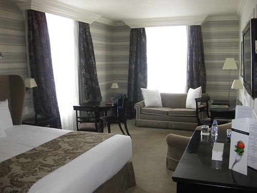
My cozy room in Dann Carlton
The view from my room. The open field is Parque La Carolina

Thursday, September 6, 2012

Travel: Bangladesh

BANGLADESH IN BRIEF
     Bangladesh is officially known as People's Republic of Bangladesh and located in South Asia. It is on the Bengal region of the eastern Indian sub continent. The name of the country means "Country of Bengal" in their official language which is Bengali. Neighboring countries are Burma (Myanmar) and India.
     The currency being used by Bangladesh is Taka (BDT), approximately $0.0123 USD. Timezone is BST (UTC +6). They drive on the left side of the road and traffic jams are normal everyday sight specially if you are on the cities. Concentration of heavy traffic is noticeable in their capital city, Dhaka. It is advisable to give about 2 hours allowance for travel if you are going out for business meetings.

HOW TO GET THERE
     Main gateway to the country is Dhaka through Shahjalal International Airport although other airlines use Chittagong and Sylhet as the point of entry. Please check wikitravel's information about travelling to Bangladesh for more details.

Thursday, May 31, 2012

Pictures: Old Phones

Been back from a long assignment abroad, I got a chance to have a short vacation. Back at my hometown, I  have cleaned some of my old stuffs and I have stumbled upon these old pieces of technology that once upon a time were awesome.

NEC Smart network locked mobile

Ericsson and Bosh

Nokia 5110 and Nokia 3530

A pair of Nokia 3210


Saturday, January 21, 2012

Travel: Masbate, Philippines

MASBATE PROVINCE IN BRIEF
     Masbate is an island province of the Philippines that is located in the Bicol Region. It is composed  of three major islands: Masbate, Ticao and Burias. The lone city, Masbate City is located in the Masbate Island. The island of Masbate lies at the center of the Philippine archipelago between latitudes 11°43’ north and 123°09’ east and 124°5’ east. The boundaries are Ticao Pass on the north, San Bernardino Strait on the east, Visayan Sea on the south, and the Sibuyan Sea on the west.
     The general topographic feature of the province ranges from slightly undulating to rolling and from hilly to mountainous. With each island, the rugged topography is concentrated in the northeastern portion and gradually recedes to blunt hills and rolling areas in the southeast, southwest, and south.

HOW TO GET THERE
     There are so many options on how to reach masbate. You can travel by land, by sea or by air from different points of the country.

By Land
      There's a daily trip going to masbate via RORO bus which is a part of the nautical highway program of the government. The terminal of this bus is located at cubao in metro manila. The bus will  travel to Pilar, Sorsogon via national highway and then will be carried by the RORO boat from Pilar port to Masbate city port.  At the time of this writing, the fare is is just 1,050 pesos one way for aircon buses and  800pesos for one way for ordinary buses with the RORO boat fare inclusive. These RORO buses also travel out from Masbate City to other towns such as Aroroy and Mobo.

By Sea
     Just in case you don't prefer the RORO bus, you still have other option. You can also ride another bus that travels daily from Manila to Pilar, the board the RORO boat going to Masbate or better yet take the fastcraft operated by Montenegro Lines. The fastcraft is convenient and faster than the RORO boat but of course the fare is higher. Montenegro lines fastcraft schedules from Pilar to Masbate City are 8:00am, 11:30am and 3:30pm. Montenegro lines fastcraft schedules from Masbate to Pilar  are 5:00am, 8:00am and 12:00 noon. These schedules may change, please verify with Montenegro lines. Ferries also travels from Cebu City going to Masbate City port or Cataingan Port.

By Air
     This is by far the most convenient means of going to Masbate. The airport is now operational again after being closed for some time due to renovation and facility improvement. ZestAir and Air Philippines has daily flights going to Masbate City airport from Manila and vice versa. Flights schedule to Masbate and vice versa are shown below.


ATTRACTIONS
Rodeo MasbateƱo Festival
     This is an annual event which takes place in Masbate City which showcases the peoples natural skills in livestock handling, such as lassoing, wrestling, and riding cattle. Also included in the event are a fair featuring local products and exhibitions, livestock shows, animal health seminars and trade of cattle and horses. The event has taken place every summer since 1993 which usually opens with a lively parade of horseback riders.
     The highlight of the event is the rodeo competition itself. Both men and women dress up in cowboy outfits to perform stunts like lassoing on foot and on horseback, bull riding and whipping, the two-person carambola, livestock wrestling, casting down, load carrying, and other activities that is related to the handling of livestock. These events draw tourists from the rest of the Philippines and also from around the world as well as local expectators. Cowboys and bull riders of other nationalities also participate in the competitions.


Natural Sceneries
     Masbate is rich in natural wonders and breathtaking views of its coastline. Picture speaks a thousand words so just click view full post to take a look at the following pictures of lovely Masbate.